-
Title
-
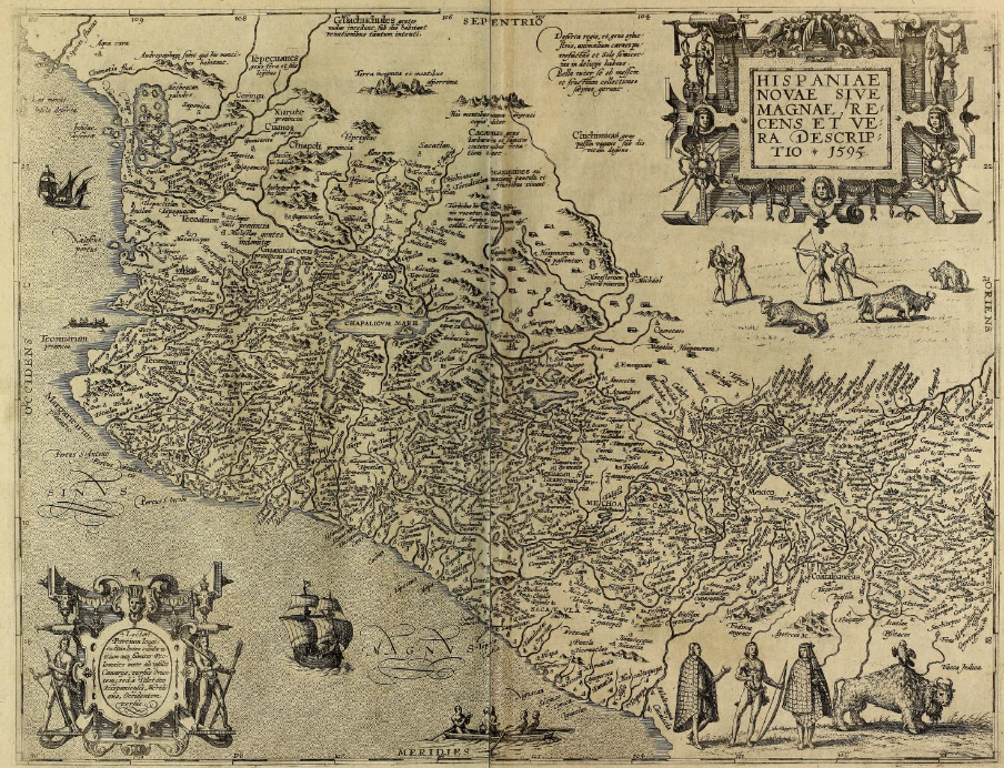
Hispaniae novae sive Magnae recens et vera descriptio. 1595.
-
Description
-
This map of the west coast of Mexico (also called New Spain at the time) was originally published by Abraham Ortelius in his work Theatrum Orbis Terrarum, first published in 1570 and considered to have been the first modern atlas. The decorative depictions of Indigenous peoples are unique to de Bry’s rendition of the map, which also includes more place names than Ortelius’ original copy. On the right below the map title, two Indigenous men stand together, both carrying bows and arrows. A man and woman stand together nearby. The man holds a spear, and the woman carries an infant on her back. On the bottom right side of the map, three Indigenous people stand together. Two of them wear feathered capes, and the person in the middle holds a bow. To the left of the trio, a group of five Indigenous people row a canoe near the shore.
-
Image Creator
-
Abraham Ortelius (Artist);Theodor de Bry (Engraver);Theodor de Bry (Printer)
-
Abraham Ortelius (Artist)
-
Theodor de Bry (Engraver)
-
Theodor de Bry (Printer)
-
Identifier
-
mta:23758
-
Source Name
-
Americæ das Fünffte Buch, Vol schöner unerhörter Historien, auß dem andern Theil Ioannis Benzonis von Meylandt gezogen: Von der Spanier Wüten, beyd wider ihre Knecht die Nigriten, und auch die arme Indianer: wie die Spanier von den Frantzösischen Meerraubern zum offtermal angriffen unnd geplündert worden, denn auch, wie sie erstlich das neuwe Spanien erfunden haben, und gantz erbärmlich mit dem armen Landvölcklein daselbst umbgangen sind.
-
Image
-
mta_23758_OBJ.png
-
Subject
-
Maps
-
Mexico – Maps – Early works to 1800
-
North America – Maps
-
Indigenous peoples - Mexico
-
Indigenous weapons – Mexico
-
Dugout Canoes
 mta_23758_OBJ.png