-
Title
-
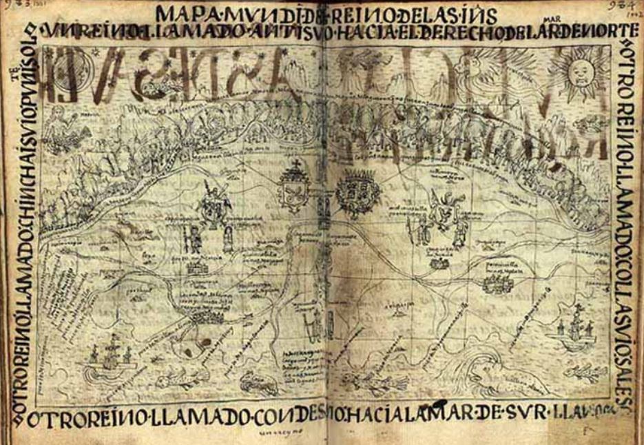
Mapa Mvndi Del Reino de las In[di]as
-
Description
-
This image is drawn over two full pages of the author’s book. It depicts a map of Tahuantinsuyu, the name that the Inca’s gave to their empire. It comprised of four regions: Chinchasuyu, Antisuyu, Condesuyu, and Collasuyu. Starting from the top left corner, the caption that runs around the frame of the image reads, Un reino llamado antisuio hacia el derecho de la mar de norte. Otro reino llamado collasuio sale so[l]. Otro reino llamado condesuio hacia la mar de sur, llanos. Otro reino llamado chincaisuio puni[en]te sol [A kingdom called Antisuyu to the right of the North Sea. Another kingdom called Collasuyu is in the sun. Another kingdom called Condesuyu is towards the South Sea. Another kingdom, Chinchasuyu in the setting sun]. The figures and words are difficult to make out as they are written and drawn small. There is a moon in the top left corner and a sun in the top right. Within the four regions that the author described, there are drawings of coat of arms, ships, animals, trees, and people.
-
Image Creator
-
Felipe Guaman Poma de Ayala (Illustrator)
-
Identifier
-
mta:23809
-
Source Name
-
El primer nueva corónica y buen gobierno [The First New Chronicle and Good Government]
-
Image
-
mta_23809_OBJ.jpg

 mta_23809_OBJ.jpg